Best Hikes in Mexican Hat, Utah
Location: Southeast Utah
On US-163, 146 miles west of Durango, Colorado.
Mexican Hat Hiking Trails
Distance: 3.2 - 5.6 miles (Round Trip)
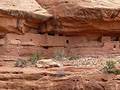
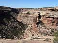
Moon House, one of the best archaeology sites on Cedar Mesa, consists of three separate structures with 49 rooms. Well preserved pictorgraphs grace the walls of an interior courtyard and some of the rooms.
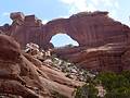
Owl Creek Canyon to Nevill's Arch ![]()
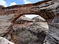
Distance: 9.6 miles (Round Trip)
This strenuous hike travels down stunningly beautiful Owl Creek Canyon to Nevill’s Arch, an imposing span located atop a high fin.
Distance: 2.8 - 4.4 miles (Round Trip)
This short hike travels down scenic Road Canyon to an amazing archaeology site with seven kivas.
Distance: 0.8 - 1.4 miles (Round Trip)
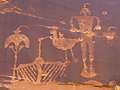
The Wolfman Panel is fascinating both for its precise artwork as well as its interesting figures. The easy access and short hiking distance make this site a popular spot for rock art enthusiasts passing through the Bluff and Mexican Hat area.
First Fork of Slickhorn Canyon ![]()
Distance: 4.9 - 9.0 miles (Round Trip)
Hikers making the very steep descent into the rugged, scenic First Fork of Slickhorn Canyon are rewarded with the opportunity to visit Perfect Kiva, one of the few kivas on Cedar Mesa that hikers are permitted to enter.
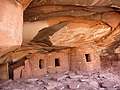
Distance: 3.0 - 12.2 miles (Round Trip)
This hike can either be done as a short, moderately-easy walk to see Fallen Roof ruins or a long, more difficult trip that also visits Seven Kivas.
Natural Bridges National Monument Loop Trail ![]()
Distance: 8.6 miles (Loop)
This great loop hike in Natural Bridges National Monument visits three majestic natural bridges, crosses a high desert landscape and wanders along two scenic canyons with rock art panels and ancestral Puebloan ruins
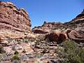
Slickhorn Canyon – Third Fork to Trail Fork ![]()
Distance: 10.5 miles (Loop)
This strenuous hike visits the scenic Third and Trail Forks of Slickhorn Canyon
View Hikes by Area:
Southeast UtahArchesCanyonlandsMoabGrand GulchBears Ears NMMonticelloMexican HatBluff