Best Hikes in Monticello, Utah
Location: Southeast Utah
On US-191, 54 miles south of Moab, UT, 104 mile northwest of Durango, Colorado and 167 miles southwest of Grand Junction, Colorado.
Monticello Hiking Trails
Distance: 5.4 - 10.9 miles (Loop)
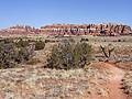
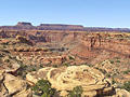
A long, entertaining circuit through a stunning landscape of sandstone spires, pinnacles, knobs, fins and monoliths surrounding a scenic expanse of desert grassland in the Needles District of Canyonlands National Park.
Distance: 10.4 miles (Round Trip)
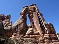
A great hike to a high bench near the head of Elephant Canyon offering spectacular views of Druid Arch, a massive, uniquely-shaped angular arch. Along the way the trail travels through scenic Elephant Canyon, beneath sandstone walls sculpted into amazing shapes.
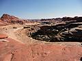
Lost Canyon/Big Spring Canyon Loop ![]()
Distance: 8.7 - 10.0 miles (Loop)
Spectacular canyon scenery awaits hikers on this varied loop hike traversing sandy washes, climbing slickrock benches and crossing steep sandstone ridges as it travels through three scenic canyons.
Distance: 0.6 miles (Loop)
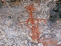
This short, entertaining hike visits an old cowboy camp and the Cave Spring alcove, harboring a spring and pictographs. Beyond the alcove the trail climbs atop a slickrock formation with fine views of nearby rock formation. Distant views stretch to the Abajo and La Sal Mountains.
Distance: 2.6 miles (Loop)
This interesting trail loops around the slickrock-topped mesa between Big Spring and Little Spring Canyons, offering good views of two canyons and surrounding landmarks. The trail is a great option for families or anyone who has never hiked on slickrock.
Distance: 0.3 miles (Loop)
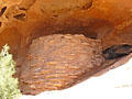
This short, easy trail leads to an Ancestral Puebloan granary tucked into a ledge above a dry wash. A self-guided trail brochure describes the plants along the trail and how they were used by the Ancestral Puebloans. This is a good introductory desert hike for children of all ages.
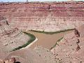
Distance: 9.8 miles (Round Trip)
This trail crosses dry, open country and ends at a cliff overlooking the confluence of the Green and Colorado Rivers, 1,000-ft. below.
View Hikes by Area:
Southeast UtahArchesCanyonlandsMoabGrand GulchBears Ears NMMonticelloMexican HatBluff