Sabrina Basin 
Distance: 6.0 - 11.8 miles (round trip)
John Muir Wilderness, Inyo National Forest, near Bishop in California's Southeastern Sierra
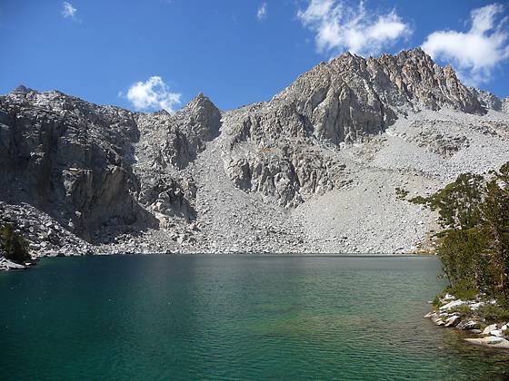
This is one of the best hikes in the Bishop area, visiting a series of beautiful lakes nestled in a dramatic basin of 13,000-ft. granite peaks.
See Trail Detail/Full Description
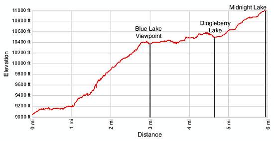
- Distance: 6.0 miles (round trip) to Blue Lake
9.2 miles (round trip) to Dingleberry Lake
11.8 miles (round trip) to Midnight Lake - Elevation: 9,050-ft. at Trailhead
10,400-ft. at Blue Lake
10,500-ft. at Dingleberry Lake
10,988-ft. at Midnight Lake - Elevation Gain: 1,350-ft. to Blue Lake
1,450-ft. to Dingleberry Lake
1,938-ft. to Midnight Lake - Difficulty: strenuous
- More Hikes in:
Bishop / Mammoth Lakes / California's Southeastern Sierra
Why Hike Sabrina Basin
Sabrina Basin is one of my favorite hikes in the Bishop area. The trail climbs the headwall at the southern end of Sabrina Lake to a wonderland of gorgeous lakes set amid glacial scoured basins surrounded by a sea of jagged granite peaks. From the upper lakes basins dramatic views encompass an impressive lineup of 13,000-ft. peaks along the Sierra Crest, including Mt. Darwin (13,831-ft.), Mt Haeckle (13,418-ft.), Mt. Powell (13,364-ft.) and Mt. Thompson (13,494-ft.).
The trail system in the basin is composed of established trails and lesser used routes. Trip options vary from a short, albeit strenuous 6-mile hike to Blue Lake to multi-day backpacks exploring each of the lakes basins. With an early start strong day-hikers can tailor a trip to visit several lakes in the lower and upper basins. Whatever option you choose you’ll not be disappointed.
Elevation Profile

Trail Resources
Trail Detail/Full Description / Trail Photo Gallery / Trail Map
Basecamp(s) Information:
Bishop / Mammoth Lakes
Region Information:
California's Southeastern Sierra
Other Hiking Regions in:
California
